

Click to enlarge.
Human beings rely on all kinds of tools to survive in our complex world and a good map is one of our most basic tools for understanding where we are and where we want to go. Maps help us get our bearings, step confidently into unfamiliar territory, and discover hidden byways and shortcuts through the larger landscape.
In an urban environment, a good map is a welcome mat inviting us into the unique neighborhoods that make up the specific landscape of that city. Public transportation and easy-to-use destination maps make perfect partners for pedestrians who want to experience the true spirit of a city.
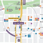
Recognizing this, Valley Metro developed new destination maps, which were installed at light rail stations in late spring. Hillary Foose, Valley Metro’s Director of Marketing & Communication, spearheaded the initiative by partnering with the City of Phoenix, Artlink, Inc. and Local First Arizona to provide a unique level of local neighborhood-specific detail that would communicate the rich destination options just steps beyond each station.
She was looking for what urbanists refer to as the “fine grain” elements of the city to provide a richer sense of place for residents and visitors alike.
“We wanted destinations to be very local,” said Foose. “That’s what makes our system interesting; we can point people to the local gems that they can walk to from each station.”
The new maps are easy to read, and each station features a “you are here” circle showing the destinations within a five-minute walk of that station. And the plan is to update the maps twice a year. Very cool.
In addition to these station maps, Valley Metro has gone the extra mile to link residents and visitors to the many arts and culture destinations accessible from the system.
 The Valley Metro Arts & Culture Destination Guide was published in March and features fifty destinations between Phoenix and Mesa.
Each page of the guide features a simple map highlighting each station stop and the major cultural attractions within easy walking distance. There are photos, venue descriptions and contact info that make it easy to use and more valuable than a compass for those who want to explore all of their arts and culture options.
Savvy visitors from around the Valley and beyond can use the station maps in combination with the Arts & Culture Destination Guide to explore, shop, eat, and experience what makes our corner of the world so special.
Next time you use the light rail, take a minute to download an Arts & Culture Destination Guide and scope out the station destination maps before you step off the platform and venture out into the hood. You’ll be amazed at the urban treasures you’ll discover in your own backyard.
Images courtesy of Valley Metro